Have you ever wondered how your car’s GPS knows exactly where you are and guides you effortlessly to your destination? It might seem like magic, but there’s a fascinating system working behind the scenes to make it all happen.
Understanding how GPS works in your car can help you trust it more and even use it better. Stick with me, and you’ll discover the simple secrets that turn satellites into your personal navigator on the road.

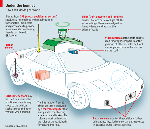
Credit: medium.com
Gps Basics
GPS helps cars know their exact location anywhere on Earth. It uses signals from satellites in space.
The system works by receiving data from many satellites at the same time. This data helps the car find where it is.
Satellite Network
GPS uses a network of about 30 satellites orbiting the Earth. These satellites send signals all the time.
Each satellite has a precise clock and knows its exact position. The car’s GPS receiver listens to these satellites.
- Satellites orbit 12,000 miles above Earth
- They send continuous radio signals
- At least four satellites are needed for location
Signal Transmission
Satellites send signals to the GPS receiver in the car. These signals travel at the speed of light.
The GPS receiver calculates how long each signal takes to arrive. This helps find the distance to each satellite.
- Signal contains time and satellite position
- Receiver measures signal travel time
- Distance = speed of light × travel time
Triangulation Method
The GPS receiver uses distances from several satellites. It finds the car’s exact spot by triangulating.
At least three satellite distances create circles. The point where they meet is the car’s location.
- Each distance forms a circle around a satellite
- Location is where circles intersect
- More satellites improve accuracy
Car Gps Components
A car GPS helps drivers find their way using satellites. It needs several parts to work well.
Each part plays a special role to provide accurate location and directions.
Gps Receiver
The GPS receiver gets signals from many satellites in space. It uses these signals to find the car’s exact location.
This part calculates the position by measuring how long signals take to arrive from satellites.
Display Unit
The display unit shows maps and directions on a screen inside the car. Drivers use it to see where to go.
It also provides voice commands and updates to help with navigation.
- Shows current location on a map
- Displays turn-by-turn directions
- Allows user to enter destinations
Antenna Role
The antenna catches signals from GPS satellites. It sends these signals to the GPS receiver inside the car.
A good antenna helps the GPS work well even in tough places like cities or forests.
Real-time Positioning
GPS in cars helps drivers know their exact location anytime. It works by connecting to satellites in space.
This system shows real-time data on your car’s position. It updates as you move to guide you safely.
Satellite Signal Processing
Satellites send signals to your car’s GPS receiver. The receiver picks up these signals to start locating your position.
- The GPS receiver listens for signals from multiple satellites.
- Each signal contains data about the satellite’s position and time.
- The receiver measures how long the signal took to arrive.
- This helps calculate the distance between the car and the satellite.
Location Calculation
The GPS system uses distances from satellites to find the car’s location. This process is called trilateration.
| Satellite | Distance to Car (km) |
| Satellite A | 20,000 |
| Satellite B | 22,000 |
| Satellite C | 19,500 |
| Satellite D | 21,000 |
The GPS receiver uses these distances to draw circles around each satellite. The car’s location is where all circles meet.
Accuracy Factors
Several things affect how exact the GPS position is. Weather, tall buildings, and signal strength matter most.
- Obstructions like trees or buildings blocking signals
- Weather conditions such as heavy rain or storms
- Quality and number of satellites in view
- Interference from electronic devices inside the car
Route Calculation
Route calculation is how a car GPS finds the best path to your destination. It uses many data points and smart methods. This helps drivers reach places quickly and safely.
The process depends on map data, algorithms, and live traffic info. Each part plays a key role in guiding the driver.
Map Data Integration
GPS systems use detailed maps to understand roads and locations. These maps include streets, highways, landmarks, and more. The system loads this data to create an accurate route.
- Road types and speed limits
- Turn restrictions and one-way streets
- Points of interest like gas stations and restaurants
- Elevation and road conditions
Pathfinding Algorithms
Algorithms find the best path by checking many possible routes. They look for the shortest or fastest way to reach the destination. Some common algorithms are:
- Dijkstra’s Algorithm
- A(A Star) Algorithm
- Bellman-Ford Algorithm
These algorithms consider distance, time, and road rules to pick the best route.
Traffic Updates
Live traffic data helps the GPS avoid slow roads and accidents. The system updates the route if there are delays. Traffic info comes from sensors, cameras, and user reports.
| Traffic Data Source | How It Helps |
| Road Sensors | Detect vehicle flow and speed |
| Traffic Cameras | Monitor congestion and incidents |
| User Reports | Provide real-time updates on accidents |
| GPS Device Data | Track average speeds on routes |
User Interaction
Using a GPS in a car helps drivers reach places easily. It shows maps and guides drivers step by step.
Drivers can interact with the GPS by touching the screen or using voice commands. This makes driving safer and more fun.
Setting Destinations
To start using the GPS, drivers must enter a destination. They can type an address or select a saved place.
- Enter address using the on-screen keyboard
- Choose places from favorites or recent destinations
- Use points of interest like gas stations or restaurants
- Set destinations by voice command for hands-free use
Voice Guidance
The GPS gives spoken directions to guide drivers. This helps keep eyes on the road and hands on the wheel.
| Voice Command | Example |
| Start Navigation | “Navigate to home” |
| Cancel Route | “Stop navigation” |
| Repeat Instruction | “Say that again” |
| Change Volume | “Turn voice up” |
Customizing Routes
Drivers can change routes to fit their needs. They can avoid tolls or highways and pick faster or shorter paths.
- Avoid toll roads
- Avoid highways
- Choose the fastest route
- Choose the shortest route
Credit: medium.com
Common Gps Challenges
GPS in cars helps drivers find their way. Sometimes, it faces challenges that affect its performance.
Understanding these challenges can help you know why your GPS might not work properly.
Signal Blockages
Buildings and tunnels can block GPS signals. This makes it hard for the device to find your location.
Tall trees and mountains can also interfere with signals. This leads to incorrect navigation instructions.
- Drive through open areas for better signal.
- Keep the GPS device in an open place inside the car.
Weather Impact
Weather can affect GPS performance. Heavy rain or snow disrupts signals, causing delays.
Cloudy skies also weaken signals. This results in slower updates on your GPS device.
- Check weather conditions before long trips.
- Update your GPS maps for better accuracy.
System Errors
GPS devices can have system errors. These errors cause wrong routes or missing locations.
Software glitches also lead to frozen screens. Regular updates help fix these issues.
- Restart your GPS if it stops working.
- Contact support for persistent problems.
Future Of Car Gps
Car GPS systems are becoming smarter every year. They help drivers find the best routes and avoid traffic.
New technology is making car GPS more useful. Let’s explore some exciting features we might see soon.
Advanced Navigation Features
Future GPS will offer real-time updates on road conditions. Drivers will know about accidents or construction ahead.
GPS will also suggest alternate routes. This helps save time and reduces stress.
- Live traffic alerts
- Weather condition updates
- Road hazard warnings
Integration With Autonomous Vehicles
Autonomous vehicles need accurate GPS to navigate. GPS helps these cars make safe driving decisions.
GPS systems will work with sensors in the car. This ensures smooth and safe rides.
- Better lane guidance
- Precision in location tracking
- Improved safety features
Enhanced Connectivity
Future GPS will connect with other devices. This means better information for drivers.
Cars will talk to each other and to traffic systems. This will make roads safer and less congested.
- Vehicle-to-vehicle communication
- Integration with smart traffic lights
- Access to updated maps and data
Credit: www.spinclabs.tech
Frequently Asked Questions
How Does Gps Locate My Car Accurately?
GPS uses signals from at least four satellites to determine your car’s exact position. It calculates distances based on signal travel time. This process, called trilateration, provides accurate location data to your car’s navigation system.
What Technology Powers Gps In Cars?
Car GPS systems rely on satellite signals and onboard receivers. These receivers process signals and calculate location in real-time. They also use digital maps and software to guide drivers efficiently.
Can Gps Work Without Internet In Cars?
Yes, GPS can work without internet since it uses satellite signals. However, internet enhances features like live traffic updates and route recalculations. Offline GPS still provides basic navigation and positioning.
How Accurate Is Car Gps Navigation?
Car GPS typically offers accuracy within 5 to 10 meters. Accuracy depends on satellite signal quality and environmental factors like tall buildings or tunnels. Modern systems use correction techniques to improve precision.
Conclusion
GPS in cars helps drivers find routes quickly and safely. It uses satellites to show exact locations on a map. This technology guides you step-by-step to your destination. It saves time and reduces stress during travel. Understanding how GPS works can make you more confident on the road.
It keeps you connected and aware of your surroundings. Trusting GPS lets you explore new places with ease. Driving becomes simpler and more enjoyable every trip.