Have you ever wondered how GPS in your car knows exactly where you are and guides you to your destination? It might seem like magic, but it’s actually a clever system working quietly behind the scenes.
Understanding how GPS works can help you use it smarter, avoid getting lost, and feel more confident on the road. You’ll discover the simple technology that powers your car’s GPS and why it’s become a must-have tool for every driver.
Keep reading to unlock the secrets behind your car’s navigation system and take control of your journeys like never before.
Credit: www.drctechno.com
Gps Technology Basics
GPS helps cars find their exact location anywhere on Earth. It uses signals from space satellites to guide drivers.
This system works all day and night, in any weather, to give accurate directions.
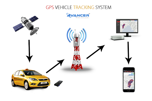
Satellite Network
GPS relies on a group of about 30 satellites orbiting Earth. These satellites send signals to GPS devices on the ground.
- Satellites circle Earth twice a day
- Each satellite sends its position and time
- The network covers the entire planet
- Satellites work together to provide signals
Signal Transmission
Satellites send radio signals to GPS receivers in cars. These signals carry important data to help find location.
| Signal Part | Purpose |
| Satellite Position | Shows where the satellite is in space |
| Time Stamp | Tells the exact time the signal was sent |
| Satellite ID | Identifies which satellite sent the signal |
Receiver Function
The GPS receiver in the car gets signals from several satellites. It calculates the car’s position by measuring signal delays.
- Receive signals from at least four satellites
- Calculate distance to each satellite using signal time
- Use distances to find exact position on Earth
- Display location on the car’s navigation system
How Car Gps Systems Work
Car GPS systems help drivers find their way using satellites. These systems give directions and maps on the car screen.
The system works by locating the car’s position and planning routes to the destination. It uses map data to show roads and places.
Position Calculation
The GPS system calculates the car’s position using signals from satellites. At least four satellites send signals at the same time.
The system measures the time it takes for the signals to reach the car. This helps find the exact location on Earth.
- Four or more satellites connect to the GPS receiver
- The receiver calculates distance from each satellite
- It uses these distances to find the car’s position
Map Data Integration
Map data shows roads, landmarks, and other important details. The GPS system uses this data to display maps on the screen.
The map data updates regularly to keep information accurate. It helps drivers know where they are and what is nearby.
- Maps include roads, highways, and streets
- Points of interest like gas stations and restaurants
- Traffic updates and road conditions may be shown
Route Planning
The GPS system plans the best route to the destination. It uses map data and current location to find the path.
The system can choose routes based on distance or time. It may update the route if there is traffic or road work.
- Calculates shortest or fastest route
- Offers turn-by-turn directions
- Adjusts route based on traffic or delays
Navigation Features In Cars
GPS technology helps drivers find their way on the road. It uses satellites to show your location on a map.
Modern cars have navigation systems that offer many useful features. These features make driving easier and safer.
Real-time Traffic Updates
GPS in cars provides live traffic information. It shows road congestion and accidents ahead.
This helps drivers avoid traffic jams and find faster routes. The system updates routes automatically if needed.
- Detects slow traffic areas
- Suggests alternate routes
- Alerts about road closures
- Updates information continuously
Voice Guidance
Voice guidance gives spoken directions to drivers. It helps keep eyes on the road and hands on the wheel.
The system tells you when to turn, change lanes, or prepare for exits. It also warns about speed limits.
- Clear, easy-to-understand instructions
- Hands-free navigation
- Alerts for upcoming turns and exits
- Speaks speed limits and warnings
Points Of Interest
Points of interest (POI) are useful places shown on the map. These include gas stations, restaurants, and hotels.
Drivers can search for nearby POIs or add them as destinations. This makes trips more convenient and planned.
- Gas stations for refueling
- Restaurants and cafes
- Hotels and accommodations
- Parking lots and rest areas

Credit: www.newindianexpress.com
Benefits Of Gps In Vehicles
GPS technology helps drivers find locations quickly and safely. It uses satellites to give real-time directions.
Many vehicles now have GPS to improve travel and save time. It supports better driving habits and planning.
Improved Safety
GPS helps drivers avoid dangerous areas and traffic jams. It gives clear routes to reduce confusion on the road.
Emergency services can find vehicles faster with GPS. This can help in accidents or breakdowns.
Fuel Efficiency
GPS guides drivers to the shortest or fastest routes. This cuts down on extra driving and saves fuel.
Less idling and fewer wrong turns lower fuel use. This helps save money and reduces pollution.
- Finds routes with less traffic
- Avoids road closures and detours
- Suggests stops for refueling efficiently
Time Savings
GPS provides real-time traffic updates to avoid delays. Drivers can plan trips better with accurate arrival times.
It helps find the quickest way to a destination. This saves time for work, errands, or travel.
Common Gps Challenges
GPS in cars helps drivers find their way by using satellites. But sometimes, GPS systems face problems that affect their performance. These issues can make navigation tricky.
Understanding common GPS challenges can help you know why your device might not work as expected. Below are some frequent problems drivers encounter.
Signal Loss
Signal loss happens when the GPS device cannot connect well to satellites. This can cause the device to stop showing your location or update it slowly.
- Driving through tunnels blocks satellite signals.
- Tall buildings in cities create “urban canyons” that interfere with signals.
- Heavy tree cover can weaken GPS signals.
- Bad weather like heavy rain or snow can reduce signal strength.
Map Accuracy
Maps in GPS devices may not always show the correct roads or paths. This can cause wrong directions or missed turns.
| Cause | Effect |
|---|---|
| Outdated map data | Missing new roads or closed streets |
| Incorrect map details | Wrong speed limits or landmarks shown |
| Limited map updates | Changes in road layouts not reflected |
Software Glitches
Software glitches are errors inside the GPS system. These bugs can cause the device to freeze, crash, or show wrong information.
Common software glitches include:
- App crashes during navigation
- Incorrect recalculation of routes
- Slow response times to user input
- Failure to load maps properly
Credit: blog.eyespysupply.com
Future Of Car Gps
Car GPS systems have evolved beyond navigation. They now play a key role in the future of driving.
Let’s explore how car GPS technology integrates with new driving innovations.
Integration With Autonomous Driving
Car GPS systems guide autonomous vehicles safely. They help in route planning and decision-making.
- Real-time traffic data analysis
- Accurate lane positioning
- Obstacle detection and avoidance
Enhanced Connectivity
GPS systems now connect cars to the internet. This allows cars to communicate with each other.
V2V (Vehicle-to-Vehicle) communication:
- Improves safety by sharing location
- Enables coordinated driving
Advanced Sensors
Advanced sensors enhance GPS accuracy. They provide precise data for navigation and safety.
| Sensor Type | Function |
| LiDAR | 3D mapping |
| Radar | Detects speed and distance |
| Cameras | Visual recognition |
Frequently Asked Questions
How Does Gps In Cars Determine Location?
GPS in cars uses satellites to calculate your exact position. It receives signals from multiple satellites and triangulates your location on Earth accurately.
What Components Make Up A Car’s Gps System?
A car’s GPS system includes a GPS receiver, antenna, and navigation software. These parts work together to provide real-time directions and location tracking.
Can Gps Work Without Internet In Cars?
Yes, car GPS can work without internet by using satellite signals. However, internet improves map updates, traffic info, and advanced navigation features.
How Accurate Is Gps In Cars For Navigation?
Car GPS systems are generally accurate within 5 to 10 meters. Accuracy depends on satellite signal strength, environment, and receiver quality.
Conclusion
GPS in cars helps drivers find the best routes quickly. It uses satellites to give accurate location data. This system works anytime, rain or shine. Drivers save time and avoid getting lost. Many cars come with built-in GPS systems today.
Understanding how GPS works makes driving easier and safer. Technology like this keeps improving every year. Simple, clear directions help everyone on the road. GPS is a useful tool for daily travel needs. It makes driving less stressful and more efficient.